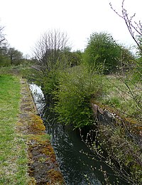
Tag:waterway=derelict_canal
Jump to navigation
Jump to search
| Description |
|---|
| A derelict artificial open waterway used for transportation, waterpower, or irrigation. |
| Group: waterways |
| Used on these elements |
| Useful combination |
|
| Status: in use |
| Tools for this tag |
|
A derelict artificial open waterway used for transportation, waterpower, or irrigation.
How to map
Consider using more specific tags using lifecycle tagging.
- disused:waterway=canal - could be easily put back into service, presumably still holds water.
- abandoned:waterway=canal - likely to have siltation, be intermittent, or be drained - this one may need additional tags to disambiguate whether it actually contains water.
- demolished:waterway=canal - filled in, but still signs on the ground
waterway=derelict_canal may mean any of above and therefore is unclear.
To map a derelict canal make a simple way. Add the waterway=derelict_canal tag to it. You should also add a name with name=* if it's known.
When mapping a disused or abandoned canal, you could map the ways representing sections that are dry with this tag, and the sections that are in water with waterway=canal.
Example
See also
- waterways: general waterway mapping information


